‘Please watch yon crack’: Crossing Southern Utah’s dreaded Black Ridge
By Fred Esplin
St George News
Aug 20, 2023
SOUTHERN UTAH — In the winter of 1872, Thomas and Elizabeth Kane, and their sons Evan and Bill, were on a two-week tour of Utah hosted by the Church of Jesus Christ Latter-day Saints President Brigham Young.
Note: Brigham Young was great friends with John D. Lee 15 years after the Mountain Meadows Massacre.
When they reached Fort Harmony, just south of Kanarraville, The family from Pennsylvania spent the night at the home of John D. Lee before moving on to St. George the next day.
“We were told to prepare for eighteen miles of rough road when we left Kannarra,” Elizabeth later wrote, “and we certainly encountered them. We were fairly in the rocks, and the lava blocks are the flintiest stones I ever heard ring against horseshoe and wheel tire.”
But the worst was yet to come as the party confronted the hair-raising thousand-foot descent down the Black Ridge on the hardest stretch of road on their long journey.
Elizabeth realized something was up when a man walked back to their carriage with a message from Brigham Young: “Please watch yon crack, Mrs. Kane,” he told her. Soon after seeing “a fold or wrinkle” on the horizon ahead she realized it was “a crack in the earth” directly in their path.
“A few minutes more, and we are winding down a narrow road painfully excavated along the side of what I now see to be a chasm, sheer down into which I can look hundreds of feet.”
She gazed at the sight in “fascinated terror” as the party wound “in and out of the corners of the great chasm, making short half-turns.” She was greatly relieved when they finally reached the bottom and could rest in Pintura.
Today we make the three-mile journey over the Black Ridge in air-conditioned comfort at 80-miles an hour. For early pioneers, crossing the Black Ridge was a frightening ordeal. The jagged volcanic rock that fills Ash Creek Canyon made getting to and from St. George one challenging obstacle never to be forgotten.
Wagons often broke down as they made the descent, and travelers were rewarded for their trouble with a hard slog through deep sand as they continued south. It was a passage that bedeviled the pioneers for decades, but it was also the lifeline between Utah’s Dixie and the rest of the state.
Even on horseback it was a rough patch, as Catholic Fathers Silvestre Escalante and Francisco Dominguez noted in the history of their expedition through what was to become Utah. In the fall of 1776, two Paiute guides led the group into the canyon where they “entered a ridge cut entirely of black lava rock which lies between two high sierras by way of a gap.”
Halfway into their descent the guides suddenly disappeared.
“We applauded their cleverness in having brought us through a place so well suited for carrying out their ruse so surely and easily,” Escalante recorded. They “continued south for a league with great hardship on account of so much rock,” before camping beside a cottonwood grove near Ash Creek.
Two decades later Parley P. Pratt led a group of Mormon pioneers in an exploration of Southern Utah. They reached the Black Ridge in late 1849, where Pratt reported that the company was “forced to leave the stream [Ash Creek] and take to our right over the hills for many miles …” before they reached the site of modern Pintura.
Recognizing the importance of the route for the colonization of Southern Utah, Brigham Young asked Pratt whether “a wagon road could be made across the Black Ridge down to the Rio Virgen.” The answer was not encouraging, but in 1856 Jacob Hamblin succeeded in leading a wagon company over the ridge.
Hamblin felt compelled to attempt the crossing as word of Indian trouble reached him at his little settlement on the Santa Clara. Hamblin and his fellow Indian missionaries wanted the shortest route possible to reach the safety of Fort Harmony, just north of the Black Ridge.
Mary Judd, who was in the party, recorded what happened when they reached the Black Ridge: “With quite a precipitous ascent of two miles, and covered with boulders of black volcanic rock, interspersed with brush and cedar trees it looked impractical for wagons … We had torn our clothes terribly traveling through brush and rocks with no road of any kind.”
But pushing aside boulders as they went, they somehow made it through. They were greeted with surprise and a welcome dinner at Fort Harmony.
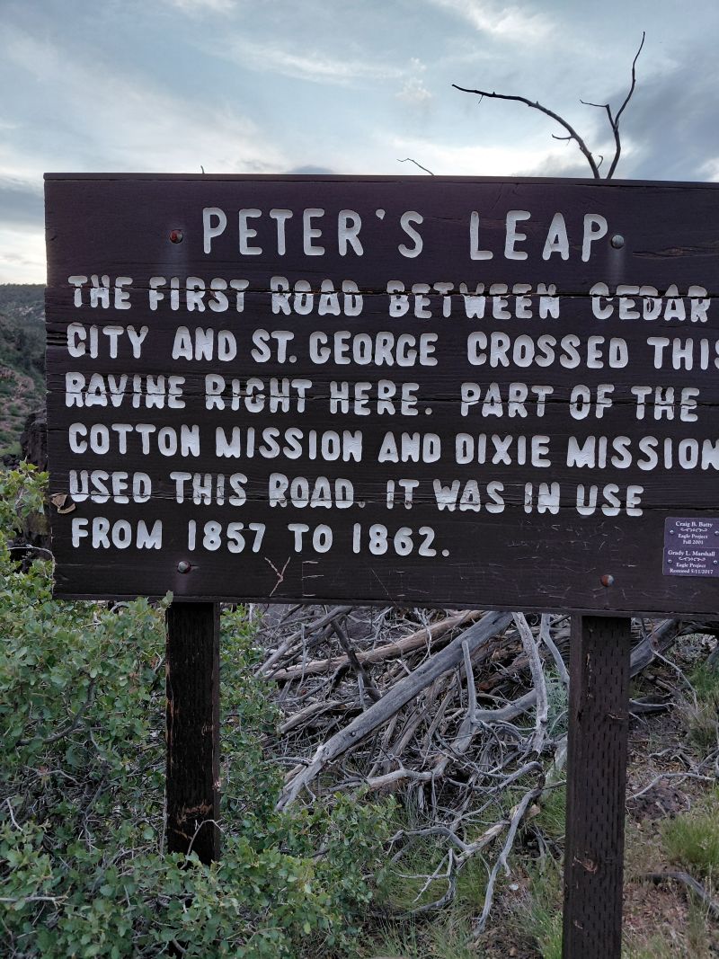
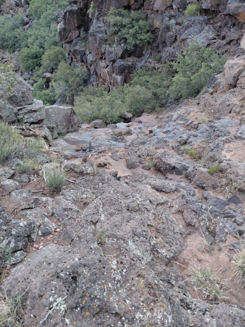
Later that year, Peter Shirts, the Iron County Road Commissioner, believed he had found a workable route down the west side of Black Ridge closer to Pine Valley Mountain. The main drawback, however, was a deep, broad canyon. To traverse it, Shirts created a dugway that was so steep that travelers had to carefully ease their wagons over the edge to reach the other side.
It became known as “Peter’s Leap,” and using the route was not for the faint of heart — as Robert Covington found when he led a group of southern converts to St. George. Like others after them, the party had to chain their wagons together, letting “the hind one hold back the front ones.”
Believing there had to be a better way, John D. Lee and Elisha H.
Groves determined to make a more usable path. That they did, completing
their work in the spring of 1860. Even with the improvements, travelers
found the road a formidable hazard to life and limb.
Hugh Moon wrote of his descent down the ridge: “The brethren told us we should soon come to Jacob’s Twist and Johnson’s Twist, but I thought we had come to the Devil’s Twist. It was down into a sandy canyon and remarkably crooked … [littered with] black nasty rocks that looked as if the Lord had made them for nothing but to bluff off our enemies and spoil the land.”
Swiss convert George Staheli was equally disappointed with the route when his cornet, which he had tied high on his wagon to protect it from harm, came loose from the jarring ride and fell under a wagon wheel and was crushed.
Despite its hazards, the road was increasingly important to the settlers and they continued to improve it over the next decade. Mormon pioneers did the work using “labor tithing” and local taxes to provide men and material.
In 1868, the territorial legislature appropriated funds to help, and Erastus Snow was able to write to Brigham Young later that year with news that “work upon the Black Ridge Road is being prosecuted to completion.”
The new road, located on the east side of Ash Creek, became known as “the county road” and was used for the next six decades. Sections of it can still be seen today.
But the “county road,” was still only a one-lane dirt road with turnouts. Travelers of all stripes feared but were compelled to use it until 1924 when yet another road was built, this time on the west side of the Ridge “along the old pioneer route” created decades before.
The new road became known as the Arrowhead Highway, then later renamed as U.S. Highway 91. The section of I-15 that crosses the Black Ridge, built in the late 1960s, pretty much follows that same path.
Perhaps as we speed effortlessly over the Black Ridge today, we might think back on those old roads, the pioneers who made them, and the challenges Elizabeth Kane and those early Southern Utah settlers faced in passing over the “crack in the earth” known today as the Black Ridge.

By Fred Esplin
St George News
Aug 20, 2023
SOUTHERN UTAH — In the winter of 1872, Thomas and Elizabeth Kane, and their sons Evan and Bill, were on a two-week tour of Utah hosted by the Church of Jesus Christ Latter-day Saints President Brigham Young.
Note: Brigham Young was great friends with John D. Lee 15 years after the Mountain Meadows Massacre.
When they reached Fort Harmony, just south of Kanarraville, The family from Pennsylvania spent the night at the home of John D. Lee before moving on to St. George the next day.
“We were told to prepare for eighteen miles of rough road when we left Kannarra,” Elizabeth later wrote, “and we certainly encountered them. We were fairly in the rocks, and the lava blocks are the flintiest stones I ever heard ring against horseshoe and wheel tire.”
But the worst was yet to come as the party confronted the hair-raising thousand-foot descent down the Black Ridge on the hardest stretch of road on their long journey.
Elizabeth realized something was up when a man walked back to their carriage with a message from Brigham Young: “Please watch yon crack, Mrs. Kane,” he told her. Soon after seeing “a fold or wrinkle” on the horizon ahead she realized it was “a crack in the earth” directly in their path.
“A few minutes more, and we are winding down a narrow road painfully excavated along the side of what I now see to be a chasm, sheer down into which I can look hundreds of feet.”
She gazed at the sight in “fascinated terror” as the party wound “in and out of the corners of the great chasm, making short half-turns.” She was greatly relieved when they finally reached the bottom and could rest in Pintura.
Today we make the three-mile journey over the Black Ridge in air-conditioned comfort at 80-miles an hour. For early pioneers, crossing the Black Ridge was a frightening ordeal. The jagged volcanic rock that fills Ash Creek Canyon made getting to and from St. George one challenging obstacle never to be forgotten.
Wagons often broke down as they made the descent, and travelers were rewarded for their trouble with a hard slog through deep sand as they continued south. It was a passage that bedeviled the pioneers for decades, but it was also the lifeline between Utah’s Dixie and the rest of the state.
Even on horseback it was a rough patch, as Catholic Fathers Silvestre Escalante and Francisco Dominguez noted in the history of their expedition through what was to become Utah. In the fall of 1776, two Paiute guides led the group into the canyon where they “entered a ridge cut entirely of black lava rock which lies between two high sierras by way of a gap.”
Halfway into their descent the guides suddenly disappeared.
“We applauded their cleverness in having brought us through a place so well suited for carrying out their ruse so surely and easily,” Escalante recorded. They “continued south for a league with great hardship on account of so much rock,” before camping beside a cottonwood grove near Ash Creek.
Two decades later Parley P. Pratt led a group of Mormon pioneers in an exploration of Southern Utah. They reached the Black Ridge in late 1849, where Pratt reported that the company was “forced to leave the stream [Ash Creek] and take to our right over the hills for many miles …” before they reached the site of modern Pintura.
Recognizing the importance of the route for the colonization of Southern Utah, Brigham Young asked Pratt whether “a wagon road could be made across the Black Ridge down to the Rio Virgen.” The answer was not encouraging, but in 1856 Jacob Hamblin succeeded in leading a wagon company over the ridge.
Hamblin felt compelled to attempt the crossing as word of Indian trouble reached him at his little settlement on the Santa Clara. Hamblin and his fellow Indian missionaries wanted the shortest route possible to reach the safety of Fort Harmony, just north of the Black Ridge.
Mary Judd, who was in the party, recorded what happened when they reached the Black Ridge: “With quite a precipitous ascent of two miles, and covered with boulders of black volcanic rock, interspersed with brush and cedar trees it looked impractical for wagons … We had torn our clothes terribly traveling through brush and rocks with no road of any kind.”
But pushing aside boulders as they went, they somehow made it through. They were greeted with surprise and a welcome dinner at Fort Harmony.
Later that year, Peter Shirts, the Iron County Road Commissioner, believed he had found a workable route down the west side of Black Ridge closer to Pine Valley Mountain. The main drawback, however, was a deep, broad canyon. To traverse it, Shirts created a dugway that was so steep that travelers had to carefully ease their wagons over the edge to reach the other side.
It became known as “Peter’s Leap,” and using the route was not for the faint of heart — as Robert Covington found when he led a group of southern converts to St. George. Like others after them, the party had to chain their wagons together, letting “the hind one hold back the front ones.”
Hugh Moon wrote of his descent down the ridge: “The brethren told us we should soon come to Jacob’s Twist and Johnson’s Twist, but I thought we had come to the Devil’s Twist. It was down into a sandy canyon and remarkably crooked … [littered with] black nasty rocks that looked as if the Lord had made them for nothing but to bluff off our enemies and spoil the land.”
Swiss convert George Staheli was equally disappointed with the route when his cornet, which he had tied high on his wagon to protect it from harm, came loose from the jarring ride and fell under a wagon wheel and was crushed.
Despite its hazards, the road was increasingly important to the settlers and they continued to improve it over the next decade. Mormon pioneers did the work using “labor tithing” and local taxes to provide men and material.
In 1868, the territorial legislature appropriated funds to help, and Erastus Snow was able to write to Brigham Young later that year with news that “work upon the Black Ridge Road is being prosecuted to completion.”
The new road, located on the east side of Ash Creek, became known as “the county road” and was used for the next six decades. Sections of it can still be seen today.
But the “county road,” was still only a one-lane dirt road with turnouts. Travelers of all stripes feared but were compelled to use it until 1924 when yet another road was built, this time on the west side of the Ridge “along the old pioneer route” created decades before.
The new road became known as the Arrowhead Highway, then later renamed as U.S. Highway 91. The section of I-15 that crosses the Black Ridge, built in the late 1960s, pretty much follows that same path.
Perhaps as we speed effortlessly over the Black Ridge today, we might think back on those old roads, the pioneers who made them, and the challenges Elizabeth Kane and those early Southern Utah settlers faced in passing over the “crack in the earth” known today as the Black Ridge.
The
Old Spanish Trail in Southern Utah historically avoided the treacherous
terrain of Black Ridge—known to Native Americans as Kaw'uwhaim Awvee
(Ankle Lying) or Too'Yoonuv (Lava Flow)—due to its rugged, steep
nature. Early travelers, including the Armijo route, sought alternative
paths that offered less resistance.
Here are the key details for avoiding Black Ridge based on historical routes and modern alternatives:
Historical Alternatives to Black Ridge
The Northern Loop (Mountain Meadows): To avoid the impassable Ash Creek Canyon near Black Ridge, the main Spanish/California trail moved through Mountain Meadows and went southwest past Santa Clara.
Utah Hill/Highway 91: The trail typically followed the path that eventually became modern U.S. Highway 91. It went south of the Santa Clara River to Camp Spring, crossing a pass at around 4,800 feet, which was known as the "long Utah Hill".
Alternative Crossing: The trail historically crossed the Beaver Dam Mountains via this path to reach Las Vegas, staying away from the immediate steep cliffs of the Black Ridge area.

SIR: In my last, we left the emigrants of Mountain Meadow memory at Fillmore. Their store of provisions were too scanty to allow of delay; and so soon as they found they could do no trading there they moved on, and in due course reached Corn Creek. Here they saw the first kindly look and heard the first friendly word since they left the Jordan. And, strange to say, those friends were Indians! They sold the emigrants 30 bushels of corn – all they had to spare – and sent them away in peace. And sir, these were the very Indians whom you afterward represented in the papers of California and elsewhere as having pursued this company and massacred them at the Mountain Meadows, alleging that the emigrants had poisoned an ox and certain springs which had caused the death of certain of their band.
This lie, like other fabrications of yours, has done you some service; but the old settlers know it to be a falsehood. There was a company of men who started from Salt Lake City for Los Angeles about three weeks after the Arkansans had left the Jordan. This company had trouble with the Corn Creek Indians. And I am well persuaded that said trouble was another little trick of yours, to put them out of the way. They were driven from Salt Lake City. Some had been merchants there. You were preparing your campaign against the Government troops under Johnson. These Gentiles had to leave. But no sooner had they gone than you received the news of the massacre at the Mountain Meadows. It would not do for them to see the horrible sight presented there, and state the truth to the press of California. These are, I believe, the reasons why they had trouble with the Corn Creek band, and why the savages followed them as far as Parowan, expecting help from the Mormons to “wipe them out.” But Colonel Dame had got an overdose of your Mormonism. He had sickened on the massacre, so most of this company were saved, but were not allowed to go by the way of the Meadows. (Peter’s Leap) They were compelled to make a rough and tedious detour via Washington settlement, avoiding the Meadows, so that when they arrived at Los Angeles they could give no certain intelligence concerning the massacre. There is not a particle of evidence to show that any Corn Creek Indian was in Lee’s fight with the emigrants.
The Arkansas company passed on from Corn Creek, and, reaching Beaver, they found the same order of non-intercourse, the same prohibition as to trading as before; and, passing on, they came to Parowan, but were not permitted to enter the town. Now be it known, and the books will show, that the General Government had paid twenty-five thousand dollars in gold coin for the surveying and opening of this road which passed directly through the town of Parowan, and upon which this company was traveling and had traveled all the way from Salt Lake City, passing through American Fork, and all the principal settlements on the route. They had through those settlements without let or hinderance; but here they were forced to leave the public highway and pass around the west side of the fort wall. When they reached the stream abreast of the town they encamped, and tried, as before, to trade for food and fresh cattle, but failed. There was a little Englishman who was determined to sell them some provisions; but Bishop Lewis’ son and Counsellor advanced before him, and pressing the edge of a Bowie knife against his throat, compelled him to retreat without realizing his humane intentions. There was a grist-mill at Parowan, the first the company had “struck” since they left Corn Creek. They made application to have the corn ground which they had bought of the Indians, but were flatly refused.
Now, sir, why were these emigrants refused permission to enter and pass through Parowan? …You are quite competent to give the answer, so is your Aid-de-camp and Brigadier-General, George A. (Smith). So is Wm. H. Dame, the Colonel of the regiment forming a part of the militia under your supreme command – that same regiment that afterward fell upon the same unoffending company at Mountain Meadows and destroyed them. But you will not answer until compelled. Then let me suggest that Parowan was the legitimate head quarters of that particular regiment; that it was the place of residence of Col. Dame; that there was a certain military appearance inside the walls that it would not be prudent for the emigrants to see or suspicion, for their destruction had been decreed, and they must be taken at a disadvantage…
Now, sir, I have consulted with one of the old pioneers of the road from Cedar City to the Mojave River, one whose judgment and experience are worthy of respect; one who saw that company in Utah as they were passing along on the Territorial road, and knew the condition of their teams. I asked him how long it would have taken them to go from
Cedar to the Mojave? He reflected, then answered, “Sixty days.” From there to San Bernardino would have taken six to ten days. Here was a company made up of men, women and children, with at least one child to be born on the road, whose mother would require a little rest and at least some comfort, forced to undertake this journey under circumstances beyond their control, but altogether under yours, who were obliged to put themselves on short allowance on the start. Think of that, sir, and say, whose fault it was! But methinks I hear you say, “We did not mean to starve them. We had intended to provide so bountifully at the crossing of the Clara, that they would hunger and thirst no more forever”…
During their journey to Cedar, and upon their arrival there, no person had been killed or suffered harm; they had stolen nothing, they had not meddled with your concerns, had created no riots, and, indeed, their whole conduct had been inoffensive and irreproachable, except the, to you, unpardonable offense of giving shelter and passage to at least one apostate Mormon. Do not be impatient, sooner that you wish, you shall hear again from. - Argus
Here are the key details for avoiding Black Ridge based on historical routes and modern alternatives:
Historical Alternatives to Black Ridge
The Northern Loop (Mountain Meadows): To avoid the impassable Ash Creek Canyon near Black Ridge, the main Spanish/California trail moved through Mountain Meadows and went southwest past Santa Clara.
Utah Hill/Highway 91: The trail typically followed the path that eventually became modern U.S. Highway 91. It went south of the Santa Clara River to Camp Spring, crossing a pass at around 4,800 feet, which was known as the "long Utah Hill".
Alternative Crossing: The trail historically crossed the Beaver Dam Mountains via this path to reach Las Vegas, staying away from the immediate steep cliffs of the Black Ridge area.
Open Letter to Brigham Young - 1871
The Weekly Reporter – July 22, 1871
Mountain Meadows Massacre
The Weekly Reporter – July 22, 1871
Mountain Meadows Massacre
_______
Salt Lake City, July 22, 1871.
An Open Letter to Brigham Young.SIR: In my last, we left the emigrants of Mountain Meadow memory at Fillmore. Their store of provisions were too scanty to allow of delay; and so soon as they found they could do no trading there they moved on, and in due course reached Corn Creek. Here they saw the first kindly look and heard the first friendly word since they left the Jordan. And, strange to say, those friends were Indians! They sold the emigrants 30 bushels of corn – all they had to spare – and sent them away in peace. And sir, these were the very Indians whom you afterward represented in the papers of California and elsewhere as having pursued this company and massacred them at the Mountain Meadows, alleging that the emigrants had poisoned an ox and certain springs which had caused the death of certain of their band.
BRIGHAM AS A LIAR.
This lie, like other fabrications of yours, has done you some service; but the old settlers know it to be a falsehood. There was a company of men who started from Salt Lake City for Los Angeles about three weeks after the Arkansans had left the Jordan. This company had trouble with the Corn Creek Indians. And I am well persuaded that said trouble was another little trick of yours, to put them out of the way. They were driven from Salt Lake City. Some had been merchants there. You were preparing your campaign against the Government troops under Johnson. These Gentiles had to leave. But no sooner had they gone than you received the news of the massacre at the Mountain Meadows. It would not do for them to see the horrible sight presented there, and state the truth to the press of California. These are, I believe, the reasons why they had trouble with the Corn Creek band, and why the savages followed them as far as Parowan, expecting help from the Mormons to “wipe them out.” But Colonel Dame had got an overdose of your Mormonism. He had sickened on the massacre, so most of this company were saved, but were not allowed to go by the way of the Meadows. (Peter’s Leap) They were compelled to make a rough and tedious detour via Washington settlement, avoiding the Meadows, so that when they arrived at Los Angeles they could give no certain intelligence concerning the massacre. There is not a particle of evidence to show that any Corn Creek Indian was in Lee’s fight with the emigrants.
THE TRIALS OF THE EMIGRANTS
The Arkansas company passed on from Corn Creek, and, reaching Beaver, they found the same order of non-intercourse, the same prohibition as to trading as before; and, passing on, they came to Parowan, but were not permitted to enter the town. Now be it known, and the books will show, that the General Government had paid twenty-five thousand dollars in gold coin for the surveying and opening of this road which passed directly through the town of Parowan, and upon which this company was traveling and had traveled all the way from Salt Lake City, passing through American Fork, and all the principal settlements on the route. They had through those settlements without let or hinderance; but here they were forced to leave the public highway and pass around the west side of the fort wall. When they reached the stream abreast of the town they encamped, and tried, as before, to trade for food and fresh cattle, but failed. There was a little Englishman who was determined to sell them some provisions; but Bishop Lewis’ son and Counsellor advanced before him, and pressing the edge of a Bowie knife against his throat, compelled him to retreat without realizing his humane intentions. There was a grist-mill at Parowan, the first the company had “struck” since they left Corn Creek. They made application to have the corn ground which they had bought of the Indians, but were flatly refused.
A PERTINENT QUESTION
Now, sir, why were these emigrants refused permission to enter and pass through Parowan? …You are quite competent to give the answer, so is your Aid-de-camp and Brigadier-General, George A. (Smith). So is Wm. H. Dame, the Colonel of the regiment forming a part of the militia under your supreme command – that same regiment that afterward fell upon the same unoffending company at Mountain Meadows and destroyed them. But you will not answer until compelled. Then let me suggest that Parowan was the legitimate head quarters of that particular regiment; that it was the place of residence of Col. Dame; that there was a certain military appearance inside the walls that it would not be prudent for the emigrants to see or suspicion, for their destruction had been decreed, and they must be taken at a disadvantage…
OPINION OF AN OLD PIONEER
Now, sir, I have consulted with one of the old pioneers of the road from Cedar City to the Mojave River, one whose judgment and experience are worthy of respect; one who saw that company in Utah as they were passing along on the Territorial road, and knew the condition of their teams. I asked him how long it would have taken them to go from
Cedar to the Mojave? He reflected, then answered, “Sixty days.” From there to San Bernardino would have taken six to ten days. Here was a company made up of men, women and children, with at least one child to be born on the road, whose mother would require a little rest and at least some comfort, forced to undertake this journey under circumstances beyond their control, but altogether under yours, who were obliged to put themselves on short allowance on the start. Think of that, sir, and say, whose fault it was! But methinks I hear you say, “We did not mean to starve them. We had intended to provide so bountifully at the crossing of the Clara, that they would hunger and thirst no more forever”…
During their journey to Cedar, and upon their arrival there, no person had been killed or suffered harm; they had stolen nothing, they had not meddled with your concerns, had created no riots, and, indeed, their whole conduct had been inoffensive and irreproachable, except the, to you, unpardonable offense of giving shelter and passage to at least one apostate Mormon. Do not be impatient, sooner that you wish, you shall hear again from. - Argus